The city core of Subotica was proclaimed a spatial cultural and historical unit in 1986 (by the decision of MZZSK Subotica No. 101-4 dated 13.12.1986), and it was established for the city core of great importance in 1991 (Official Gazette SRJ 25/91 ).
The historical core of Subotica is located on the territory of the Municipality of Subotica, comprising the central part of the settlement, in the following borders: from the east – the border makes the railway from Zmaj Jovina to the street Maksim Gorkog, or the western edge of the cat. lots 5126, with south-south regulation line of Maksim Gorkog street from the railway line to Roman street, from the west-the border is the western side of the Roman street to the Sombor road, part of the Sombor road from Romania to Mažuranićeva street, Laze Mamužić street and the western side of Karadjordje road to the street Žarka Zrenjanina, on the north-north side of Žarka Zrenjanina Street, on the north side of the Square on November 29th and the Dragon Jovina street to the railway line.
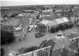
A spacious cultural and historical unit of great significance is the historical core of Subotica, which is located in the central part of the centuries-old urban matrix of the city with its inherent time stratification. All the layers of urban construction that have been continuously evolving since the fourteenth century to date are contained in this area: in the central part of the whole is the oldest part of the city with the remains of a castle from the 15th century built into the Franciscan church, as well as the shape of the cannon that has been preserved in the urban matrix of the surrounding streets. The space affected by all important road directions: eastern Segedin, South Petrova, Western Sombor and North Bay Road, today is a three-pronged place: the space between the three squares – the Square of Liberty, the Republic Square and the Square of Emperor Jovan Nenad. This junction of the roads was at the same time an entrance to the castle. An urban matrix that was originally airborne,in order to further plan development, this form has been modified, it is even today in some segments visible in the urban matrix of the core. It is known that the cemeteries have always been built on the outskirts of the settlement, which supports the claim that the original settlement was located in the area from Rogina bara in the east (now Ferenc Rajhla Park) to the old cemetery in the west (along the western edge of Matije Gupca Street). This area has retained the role of the center in further development.This area has retained the role of the center in further development.This area has retained the role of the center in further development.
Further spontaneous development of the settlement caused the configuration of the terrain. Higher parts are settled, while the central, wetland part of the settlement with watercourses has remained uninhabited. The crucial role of the watercourse that flows from the northwestern part of the city is crucial. He divided the city into two parts, on the eastern coast around the castle depicted a compact urban matrix, and in the western scattered, limited by a couple of nabbed lines. With the expansion and introduction of civil administration, the settlement gets new functions. It comes to combining two parts into a single whole. The new administrative, cultural, educational, trade and trade center was established in the central area where the main point was the new town house built in 1751, but still remains within the same framework defined by the old cemetery and Rogina Bar. All subsequent town houses will be built (the second in 1827,and today’s 1910/12.) in this area that will remain the central area of the city to this day. Marking points for the city frame were next to the city hall: the Franciscan Monastery, the Orthodox Church built in 1730, the Catholic cathedral of St. The Theresa, built in 1779, the chapel of St. Hands that were erected in 1738.
How important for the development of the market was for the next forty years it was evident on the oldest known handwriting card, which was written in 1778 by Kovács Károly Lipóth, and which details exclusively the city’s territory in detail. From this map, up to the present day, we can follow the urban and architectural development of the city. By that time, the marketplace was so much larger that the watercourse was located in the middle of the settlement, as well as the cemetery which had previously to be on the edge of the settlement. The settlement already occupied a territory whose size will not change significantly until the end of the XIX century.
With this document begins the planned urban development of the city. Then the future center of the city was defined at a place where it was continuously formed over the next period. At that time, the inner city was still poorly populated and sprinkled with watercourses and bars with many bridges, but in this plan it is already evident that the settlement of the center (udoline) has taken a maha. Today’s roads and streets, urban blocks and squares are already readable from it, as well as that the first civic houses of the long type are concentrated around the Franciscan church and at the crossroads of the roads. Urban blocks formed in this period are still an irregular shape that is adapted to the direction of the roads and the position of the waters and swamps. Most urban blocks in this part of the nucleus, as well as subdivisions, were formed until the end of the 18th century.
The first steps towards the planning of the settlements were made by setting up the administrative frameworks defined in the documents by which Saint Mary was proclaimed in 1779 as a free royal city under the name of Maria Tereziopolis. The Statute provided various provisions on the construction and arrangement of the city territory, with the aim of making the town a city as soon as possible. In the following years, and in accordance with the obligations that the city took over, the construction plans for urban planning and hydro-engineering plans for drying of bars and watercourses were initiated. The accent was placed around the town hall. The spontaneously formed urban matrix is only regulated. The first cadastral map of 1838 clearly shows that the biggest changes were made in the central part of the city around the Franciscan church, the church of St. Theresa,the Orthodox Church and around the town house, where the civic houses were mostly built. At the beginning of the century, after the drying of the wet central area, the urban regulation of the urban matrix was almost identical to that of today.
The first important step for transforming the palace into the city is the construction of the theater in 1854. The theater represents a new benchmark for the formation of the center, which had already been marked by sacral objects and the Town Hall. The following major interventions were not carried out until the introduction of the railroad in 1869, a turning point in the development of the city. Then there is a sudden development and expansion of the city center to the area of the former Rogina bara. In the period from 1880 to 1914, the city core, especially on the section from the railway to the church of Sts. Theresa, he is fully acquainted with today’s character. Numerous, mostly one-way rented palaces were built, greening, lighting, partial sewage, paving.
In the period between the two world wars, continuation of the city construction was continued, the Sokolski dom was built with a practice around it, the street of Vladimir Nazor was decorated.
This is the end of the continuous development of the city, so that in the 60s and 70s of the twentieth century, its decommissioning began, with the construction of multi-storey freestanding buildings in the oldest part, along with the Franciscan monastery, Radnički University was erected, alongside it a large department store and residential multi-storey house. Another building managed to get into the historic core, on the perimeter of the hotel, “Patria” was built along the international road. They remained as a testimony of a European urban and architectural movement that denied the existing values, but a movement that still failed to disturb the core of the core.
Establishment of the historical city center of Subotica for a spatial cultural and historical unit of great importance, the proclamation of individual objects for cultural monuments was suspended.
CITY CORE OF SUBOTICA
0 comments on “CITY CORE OF SUBOTICA”